Pre-register point cloud data automatically in the field to expedite quality control inspections, boost output, and enable more informed decision-making on the spot.
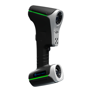
With quick, easy-to-use, precise, and portable gear and software, the Leica RTC360 3D reality capture solution enables users to record and capture their surroundings in 3D, increasing efficiency and productivity both in the office and in the field. Professionals can manage project complexity with accurate and dependable 3D representations and explore the potential of any location with the RTC360 3D laser scanner.
- The RTC360 solution effectively combines the RTC360, a high-performance 3D laser scanner, Leica Cyclone FIELD 360, a mobile device app for edge computing that automatically registers scans in real time, and Leica Cyclone REGISTER 360 PLUS office software to seamlessly integrate your 3D model into your workflow. It is highly portable, highly automated, intuitive, and designed for maximum productivity.
- In less than two minutes, capture scans that include enriched High-Dynamic Range (HDR) imagery.
- Pre-register your scans in the field without requiring human interaction by automatically recording your movements between stations.
- Enhance your data collection by adding information tags that represent site reality, highlight planning opportunities, and increase your teams’ situational awareness.
- Publish your collected data straight to Reality Cloud Studio using HxDR from Cyclone FIELD 360.
Fast
3D reality capturing is now faster than ever thanks to the Leica RTC360 laser scanner. The production of colored 3D point clouds can be finished in less than two minutes thanks to an advanced HDR photography technology and a measuring rate of up to 2 million points per second. Additionally, the smooth, automated data transfer from site to office and automatic targetless field registration (based on VIS technology) save field time and increase productivity.
Agile
With its lightweight and portable design, the Leica RTC360 scanner can be carried anywhere thanks to its collapsible tripod and small size. Once on location, scanning is quick and hassle-free thanks to an intuitive one-button interface.
Precise
Better images are made possible by low noise data, producing clear, detailed scans that can be used in a variety of applications. The Leica RTC360 scanner provides exceptional precision that can be verified on-site when used in conjunction with Cyclone FIELD 360 software for automated registration in the field.
Registraton in the field
The Cyclone FIELD 360 app, which is a component of the RTC360 system, connects the laser scanner for 3D data acquisition in the field and Cyclone REGISTER 360 PLUS for data registration in the office. The user has the ability to automatically record, register, and review scan and image data on-site. The user interface offers a great user experience, even for inexperienced users, by combining graphical user guidance with easy management of complex mathematics.
Data Sheets
Range
There are 36 possible configurations for the Absolute Arm, which comes in three versions, three accuracy levels, and seven sizes. The three accuracy levels of the Compact, Six Axis, and Seven Axis models are 83, 85, and 87. The Compact’s measurement volume has a diameter of 1.2 meters, whereas the other variants have measurement volume sizes ranging from 2.0 to 4.5 meters.